PVD NOTAMs
Rhode Island T. F. Green International Airport, Providence, RI · KPVD
Rhode Island T. F. Green International Airport in Providence, Rhode Island (IATA PVD, ICAO KPVD) has 36 current NOTAMs (Notices to Air Missions): 23 in effect now and 13 starting later. By category: runways (13), procedures (6) and navaids (4). The list comes from the FAA NOTAM Management Service, refreshed by cwsi.net every few minutes; each NOTAM shows its number, category, start and end time in UTC, and a plain-English reading.
- Runway13
- Procedures6
- Navaid4
- Taxiway4
- Obstacle3
- Apron2
- Services2
- Aerodrome1
- Airspace1
In effect now (23)
RWY 05/23 WIP CONST 2611161736-2611201000
RWY 05/23 CLSD EXC XNG DLY 0300-1000 2611160300-2611181000
RWY 05/23 WIP CONST DLY 0300-1000 2611160300-2611181000
AIRSPACE UAS WI AN AREA DEFINED AS 4NM RADIUS OF 414211.30N0712730.60W (1.8NM WSW PVD) SFC-200FT AGL DLY 0000-2359 2611170000-2611222359
OBST TOWER LGT (ASN 2022-ANE-3907-OE) 413959N0712913W (4.3NM SW PVD) 279FT (90FT AGL) U/S 2611130328-2611270328
OBST TOWER LGT (ASN 2022-ANE-3905-OE) 414010N0712908W (4.1NM SW PVD) 269FT (100FT AGL) U/S 2611130328-2611270328
RWY 16 RWY END ID LGT U/S 2611110751-2611182300
OBST BLDG (ASN 1996-ANE-269-OE) 414359N0712532W (0.6NM NNE PVD) 90FT (38FT AGL) NOT LGTD 2611070328-2611302359
AD AP FRICTION MEASURING DEVICE U/S 2610291147-2612312359
APRON SOUTH CARGO RAMP CLSD 2610290903-2612312359
SVC TAR/SSR U/S 2610191200-2612292100
IAP RHODE ISLAND TF GREEN INTL, PROVIDENCE, RI. RNAV (RNP) Z RWY 23, ORIG-B... RNP 0.30 DA 491/HAT 441. TEMPORARY CRANE 166FT MSL 119FT AGL 6617FT NE OF APCH END RWY 23 (2025-ANE-3935-OE). 2609031446-2702052355EST
TWY T BTN TWY C AND TWY M CLSD TO ACFT WINGSPAN MORE THAN 118FT 2608222159-2612312359
TWY V BTN TWY T AND TWY C CLSD 2608222159-2612312359
APRON REMAIN OVERNIGHT PRKG CLSD 2606272148-2612312359
IAP RHODE ISLAND TF GREEN INTL, PROVIDENCE, RI. RNAV (GPS) Y RWY 23, AMDT 2C... LNAV/VNAV DA 452/HAT 402. TEMPORARY CRANE 166FT MSL 119FT AGL 6617FT NE OF APCH END RWY 23. 2025-ANE-3935-OE. 2606261407-2702052355EST
IAP RHODE ISLAND TF GREEN INTL, PROVIDENCE, RI. ILS OR LOC RWY 23, AMDT 8A... WIVPA FIX MINIMUMS, S-LOC 23 MDA 420/HAT 370. TEMPORARY CRANE 166FT MSL 119FT AGL 6617FT NE OF APCH END RWY 23. 2025-ANE-3935-OE. 2606261406-2702052355EST
TWY T RUNUP PAD CLSD 2605252349-2612312359
IAP RHODE ISLAND TF GREEN INTL, PROVIDENCE, RI. ILS OR LOC RWY 5, AMDT 20... ILS RWY 5 (CAT II-III), AMDT 20... PROFILE NOTE: VGSI AND ILS GLIDEPATH NOT COINCIDENT (VGSI ANGLE 3.00/TCH 69). 2605181534-2805181534EST
IAP RHODE ISLAND TF GREEN INTL, PROVIDENCE, RI. RNAV (GPS) RWY 5, AMDT 1... PROFILE NOTE: VGSI AND RNAV GLIDEPATH NOT COINCIDENT (VGSI ANGLE 3.00/TCH 69). 2604281247-2804301247EST
RWY 05 NAV ILS REDUCED LGT SPECIAL AUTH CAT II AVAIL 2604140200-2611202359
RWY 05/23 RCLL U/S 2604140200-2611202359
IAP RHODE ISLAND TF GREEN INTL, PROVIDENCE, RI. RNAV (GPS) RWY 5, AMDT 1... VGSI AND RNAV GLIDEPATH NOT COINCIDENT (VGSI ANGLE 3.00/TCH 69). 2505121856-2705131856EST
Starting later (13)
TWY M1, M2, TWY T BTN RWY 05/23 AND TWY M, TWY N BTN RWY 05/23 AND TWY M, TWY A BTN APCH END RWY 23 AND TWY M, TWY M BTN SOUTH CARGO RAMP AND TWY M1, TWY B BTN RWY 16/34 AND TWY M CLSD 2611170300-2611171000
NAV ILS RWY 34 U/S 2611171300-2611172100
RWY 05/23 CLSD EXC XNG DLY 0300-1000 2611170300-2611201000
RWY 05/23 WIP CONST DLY 0300-1000 2611170300-2611201000
RWY 23 ALS U/S DLY 0300-1000 2611170300-2611201000
RWY 05 ALS U/S DLY 0300-1000 2611170300-2611201000
RWY 05 ALS U/S 2611170300-2611201000
RWY 05 PAPI U/S DLY 0300-1000 2611170300-2611201000
NAV ILS RWY 05 U/S DLY 0300-1000 2611170300-2611201000
NAV ILS RWY 23 U/S DLY 0300-1000 2611170300-2611201000
NAV ILS RWY 23 SPECIAL AUTH CAT I/II NA 2611171330-2611171430
RWY 23 ALS U/S 2611171330-2611171430
SVC SMR U/S 2611191500-2611191900
Airport diagram

FAA chart (PNG) Official FAA PDF (effective Oct 29 to Nov 26)
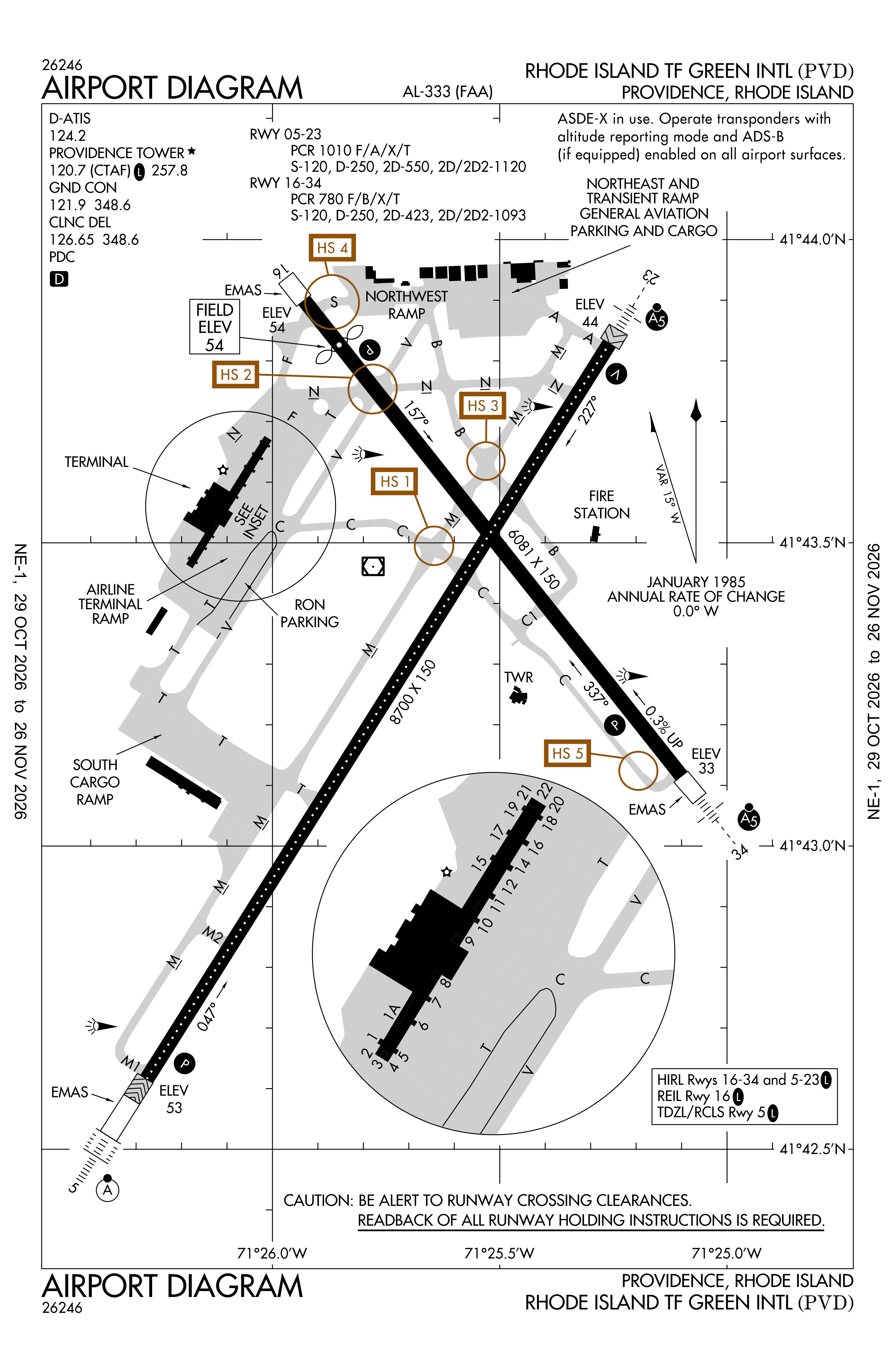
Redrawn by cwsi.net from the FAA airport diagram, cycle 2611, effective Oct 29 to Nov 26, 2026, and OpenStreetMap. Reference only, not for navigation.
FBOs and services
FBOs
 Atlantic Aviation Warwick544 Airport Road, Warwick, RI+1 401-738-2600Hours: Mon-Sun: 0500-2400 On-call services with prior arrangementsAtlantic page
FBO details may be out of date. Call ahead to confirm services and hours.
Not listed? Send a correction.
As of Nov 5, 2026.
Related
- Interactive NOTAM search for KPVD (category filters, maps, share links and a NOTAM decoder)
- Rhode Island T. F. Green International Airport: codes, map and current weather
- PVD weather and runway winds (METAR and TAF in plain English)
- Flights at PVD now
- NOTAMs for other US airports
More NOTAMs in Rhode Island
Times are UTC (Z). Plain-English explanations are generated by cwsi.net from the NOTAM abbreviations and may simplify; the original NOTAM text is authoritative. NOTAMs come from the FAA NOTAM Management Service; cwsi.net refreshes its copy every 3 minutes. cwsi.net is not affiliated with the FAA: always confirm NOTAMs through official sources (a standard briefing or FAA NOTAM Search) before flight.