PSM NOTAMs
Portsmouth International Airport at Pease, Portsmouth, NH · KPSM
Portsmouth International Airport at Pease in Portsmouth, New Hampshire (IATA PSM, ICAO KPSM) has 10 current NOTAMs (Notices to Air Missions): 10 in effect now and 0 starting later. By category: aprons (4), navaids (2) and procedures (2). The list comes from the FAA NOTAM Management Service, refreshed by cwsi.net every few minutes; each NOTAM shows its number, category, start and end time in UTC, and a plain-English reading.
- Apron4
- Navaid2
- Procedures2
- Taxiway2
In effect now (10)
APRON TXL K CL MARKINGS NOT STD 2611041556-2612010459
TWY A SOUTH RUN UP PAD HLDG PSN MARKINGS FOR TWY A NOT STD 2611010153-2612010500
APRON NORTH APN CLSD TO FIXED WING AND ROTARY WING 2611010144-2612010500
APRON GND RUNUP ENCLOSURE CLSD 2611010142-2612010500
IAP PORTSMOUTH INTL AT PEASE, PORTSMOUTH, NH. ILS OR LOC RWY 34, AMDT 4... ALTERNATE MINIMUMS NA EXCEPT FOR ACFT EQUIPPED WITH SUITABLE RNAV SYSTEM WITH GPS, ENE VOR/DME UNMONITORED. 2610241424-2611062359EST
NAV ILS RWY 34 U/S 2610151757-2611192359
TWY D CLSD EXC BASED MIL ACFT 2610141551-2611151700
NAV ILS RWY 34 GP U/S 2609081854-2612182359
IAP PORTSMOUTH INTL AT PEASE, PORTSMOUTH, NH. RADAR 1, AMDT 1A... PROCEDURE NA. 2609041434-2809042359EST
APRON SOUTH MAINT APN CLSD 2512010221-PERM
Airport diagram
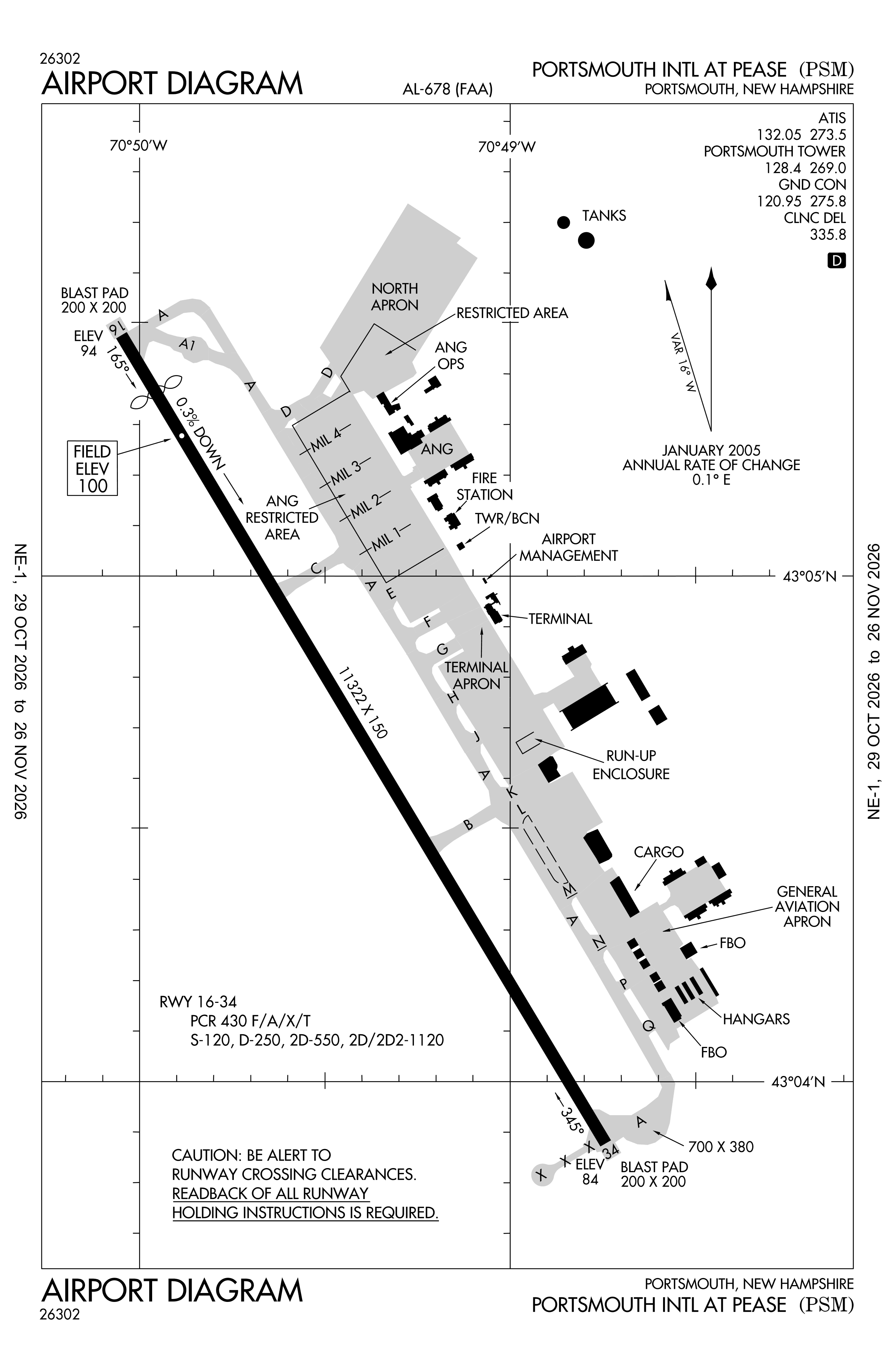
Official FAA PDF (effective Oct 29 to Nov 26)
FAA airport diagram, cycle 2611, effective Oct 29 to Nov 26, 2026. Reference only, not for navigation.
FBOs and services
FBOs
No FBOs are listed in OpenStreetMap for this airport.
Not listed? The FBO may not be in OpenStreetMap. Send a correction.
Data © OpenStreetMap contributors (ODbL), as of Nov 3, 2026.
Related
- Interactive NOTAM search for KPSM (category filters, maps, share links and a NOTAM decoder)
- Portsmouth International Airport at Pease: codes, map and current weather
- PSM weather and runway winds (METAR and TAF in plain English)
- Flights at PSM now
- NOTAMs for other US airports
More NOTAMs in New Hampshire
Times are UTC (Z). Plain-English explanations are generated by cwsi.net from the NOTAM abbreviations and may simplify; the original NOTAM text is authoritative. NOTAMs come from the FAA NOTAM Management Service; cwsi.net refreshes its copy every 3 minutes. cwsi.net is not affiliated with the FAA: always confirm NOTAMs through official sources (a standard briefing or FAA NOTAM Search) before flight.