MSO NOTAMs
Missoula Montana Airport, Missoula, MT · KMSO
Missoula Montana Airport in Missoula, Montana (IATA MSO, ICAO KMSO) has 13 current NOTAMs (Notices to Air Missions): 13 in effect now and 0 starting later. By category: runways (4), obstacles (3) and procedures (3). The list comes from the FAA NOTAM Management Service, refreshed by cwsi.net every few minutes; each NOTAM shows its number, category, start and end time in UTC, and a plain-English reading.
- Runway4
- Obstacle3
- Procedures3
- Taxiway2
- Services1
In effect now (13)
RWY 30 FICON 5/5/5 100 PCT WET OBS AT 2611162303. 2611162303-2611172303
RWY 30 FICON 5/5/5 100 PCT WET OBS AT 2611161636. 2611161636-2611171636
TWY ALL FICON WET OBS AT 2611161002. 2611161002-2611171002
RWY 30 FICON 5/5/5 100 PCT WET OBS AT 2611161000. 2611161000-2611171000
SVC SSR U/S 2611132312-2611202000EST
TWY G BTN RWY 12/30 AND APCH END RWY 08 CLSD 2611031212-2801012359
OBST TOWER LGT (ASR 1052356) 464948.00N1140449.00W (5.2NM S MSO) 3333.0FT (213.3FT AGL) U/S 2611021722-2701042359
OBST TOWER LGT (ASR 1052355) 464945.00N1140448.00W (5.3NM S MSO) 3566.3FT (446.5FT AGL) U/S 2611021722-2701042359
OBST TOWER LGT (ASR 1332068) 470558.50N1140230.30W (11.2NM N MSO) 4019FT (324FT AGL) U/S 2610271326-2612111926
IAP MISSOULA MONTANA, MISSOULA, MT. VOR-A, AMDT 13... CIRCLING MDA 5380/HAA 2174 ALL CATS. 2512011809-2712011808EST
IAP MISSOULA MONTANA, MISSOULA, MT. ILS Y RWY 12, ORIG-C... S-ILS 12 DA 5026/HAT 1826 ALL CATS. 2512011808-2712011808EST
RWY 08/26 CLSD 2508041855-PERM
IAP MISSOULA MONTANA, MISSOULA, MT. RNAV (GPS) Y RWY 12, AMDT 3... RNAV (GPS)-D, AMDT 1... VOR-A, AMDT 13... VOR-B, AMDT 7... CIRCLING NA TO RWYS 08 AND 26. 2507241756-2707241755EST
Airport diagram

FAA chart (PNG) Official FAA PDF (effective Oct 29 to Nov 26)
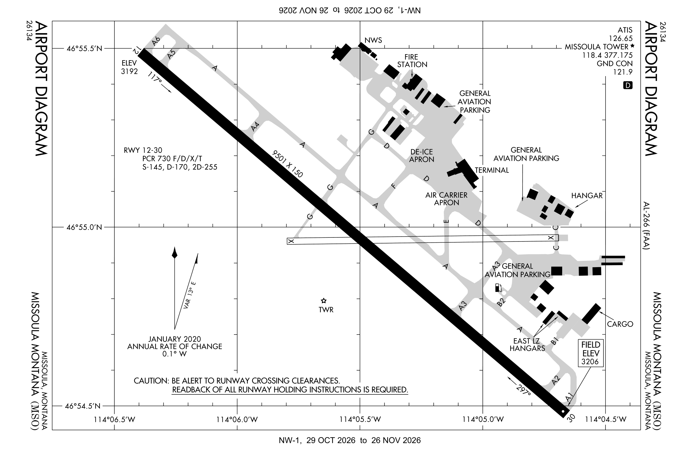
Redrawn by cwsi.net from the FAA airport diagram, cycle 2611, effective Oct 29 to Nov 26, 2026, and OpenStreetMap. Reference only, not for navigation.
FBOs and services
Related
- Interactive NOTAM search for KMSO (category filters, maps, share links and a NOTAM decoder)
- Missoula Montana Airport: codes, map and current weather
- MSO weather and runway winds (METAR and TAF in plain English)
- Flights at MSO now
- NOTAMs for other US airports
More NOTAMs in Montana
Times are UTC (Z). Plain-English explanations are generated by cwsi.net from the NOTAM abbreviations and may simplify; the original NOTAM text is authoritative. NOTAMs come from the FAA NOTAM Management Service; cwsi.net refreshes its copy every 3 minutes. cwsi.net is not affiliated with the FAA: always confirm NOTAMs through official sources (a standard briefing or FAA NOTAM Search) before flight.