MKK NOTAMs
Molokai Airport, Kaunakakai, HI · PHMK
Molokai Airport in Kaunakakai, Hawaii (IATA MKK, ICAO PHMK) has 21 current NOTAMs (Notices to Air Missions): 15 in effect now and 6 starting later. By category: taxiways (5), aerodromes (4) and runways (4). The list comes from the FAA NOTAM Management Service, refreshed by cwsi.net every few minutes; each NOTAM shows its number, category, start and end time in UTC, and a plain-English reading.
- Taxiway5
- Aerodrome4
- Runway4
- Procedures3
- Navaid2
- Services2
- Obstacle1
In effect now (15)
IAP MOLOKAI, KAUNAKAKAI, HI. VOR OR TACAN-A, AMDT 17A... ALTERNATE MINIMUMS NA EXCEPT FOR ACFT EQUIPPED WITH SUITABLE RNAV SYSTEM WITH GPS, MKK VORTAC UNMONITORED. 2611041814-2611182359EST
NAV VORTAC NOT MNT 2611041714-2611182359EST
RWY 17/35 CLSD 2610282142-2611302300
TWY D SFC MARKING NOT STD 2610282120-2611302300
RWY 23 THR MARKINGS NOT STD 2610282118-2611302300
AD AP WINDCONE FOR RWY 05 LGT U/S 2610282118-2611302300
AD AP WINDCONE FOR RWY 35 LGT U/S 2610282117-2611302300
AD AP ALL SFC WIP CONST N SIDE 2610282113-2611302300
TWY E HLDG PSN SIGN FOR RWY 17/35 LGT U/S 2610282053-2611302300
TWY E BTN RWY 17/35 AND TWY D CLSD 2610282052-2611302300
AD AP WINDCONE FOR RWY 23 LGT U/S 2610282052-2611302300
TWY D HLDG PSN SIGN FOR RWY 17 NOT STD MISSING 2610282050-2611302300
RWY 05/23 SAFETY AREA WIP HUMPS AND RUTS 2610282050-2611302300
RWY 17/35 SAFETY AREA WIP HUMPS AND RUTS 2610282049-2611302300
OBST POLE (ASN UNKNOWN) 210811N1570701W (1.49NM SW APCH END RWY 05) UNKNOWN (60FT AGL) NOT LGTD 2610280010-2611302200
Starting later (6)
SID MOLOKAI, KAUNAKAKAI, HI. HAPAI THREE DEPARTURE... DEPARTURE PROCEDURE NA EXCEPT FOR ACFT EQUIPPED WITH SUITABLE RNAV SYSTEM WITH GPS, MKK VORTAC OUT OF SERVICE. 2611051745-2611060500EST
ODP MOLOKAI, KAUNAKAKAI, HI. KAUNAKAKAI ONE DEPARTURE ... DEPARTURE PROCEDURE NA EXCEPT FOR ACFT EQUIPPED WITH SUITABLE RNAV SYSTEM WITH GPS, MKK VORTAC OUT OF SERVICE. 2611051745-2611060500EST
SVC TWR CLSD MNT CTAF 125.7 2611080230-2611110430
SVC TWR CLSD MNT CTAF 125.7 DLY 1600-1630 2611071600-2611101630
TWY A BTN APCH END RWY 05 AND TWY E CLSD CONSTRUCTION DLY 1600-0400 2611091600-2611210400
NAV VORTAC U/S 2611051745-2611060500
Airport diagram
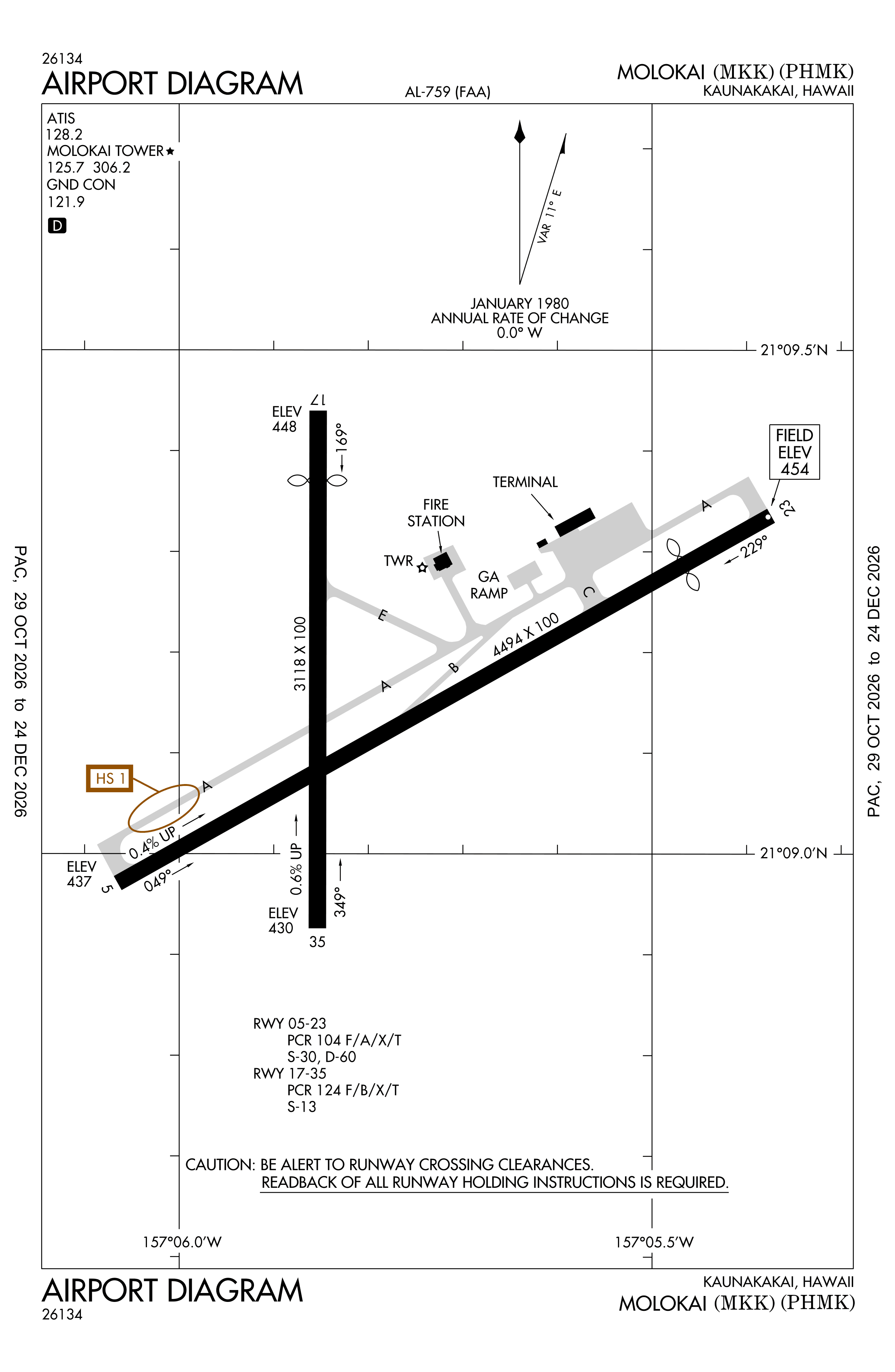
Official FAA PDF (effective Oct 29 to Nov 26)
FAA airport diagram, cycle 2611, effective Oct 29 to Nov 26, 2026. Reference only, not for navigation.
FBOs and services
FBOs
No FBOs are listed in OpenStreetMap for this airport.
Not listed? The FBO may not be in OpenStreetMap. Send a correction.
Data © OpenStreetMap contributors (ODbL), as of Nov 3, 2026.
Related
- Interactive NOTAM search for PHMK (category filters, maps, share links and a NOTAM decoder)
- Molokai Airport: codes, map and current weather
- MKK weather and runway winds (METAR and TAF in plain English)
- Flights at MKK now
- NOTAMs for other US airports
More NOTAMs in Hawaii
Times are UTC (Z). Plain-English explanations are generated by cwsi.net from the NOTAM abbreviations and may simplify; the original NOTAM text is authoritative. NOTAMs come from the FAA NOTAM Management Service; cwsi.net refreshes its copy every 3 minutes. cwsi.net is not affiliated with the FAA: always confirm NOTAMs through official sources (a standard briefing or FAA NOTAM Search) before flight.