MEI NOTAMs
Key Field, Meridian, MS · KMEI
Key Field in Meridian, Mississippi (IATA MEI, ICAO KMEI) has 21 current NOTAMs (Notices to Air Missions): 21 in effect now and 0 starting later. By category: obstacles (11), taxiways (4) and aprons (2). The list comes from the FAA NOTAM Management Service, refreshed by cwsi.net every few minutes; each NOTAM shows its number, category, start and end time in UTC, and a plain-English reading.
- Obstacle11
- Taxiway4
- Apron2
- Runway2
- Aerodrome1
- Services1
In effect now (21)
OBST TOWER LGT (ASR 1214347) 322534.40N0884727.60W (5.9NM NNW MEI) 685.0FT (359.9FT AGL) U/S 2611050040-2702030040
TWY B3 CLSD 2611021700-2611132200
TWY B5 CLSD 2611021700-2611132200
TWY B BTN APCH END RWY 22 AND AREA 51 RAMP CLSD 2611021700-2611132200
RWY 04/22 CLSD 2611021700-2611132200
OBST TOWER LGT (ASR 1215148) 323726.00N0882957.60W (21.8NM NE MEI) 619.8FT (302.8FT AGL) U/S 2610290758-2702260758
OBST TOWER LGT (ASR 1271202) 322153.60N0884357.90W (2.2NM NNE MEI) 534.1FT (161.1FT AGL) U/S 2610290546-2611130446
OBST TOWER LGT (ASR 1280315) 323349.80N0885311.90W (15.3NM NNW MEI) 1107.9FT (609.9FT AGL) U/S 2610252347-2611092247
OBST TOWER LGT (ASR 1212542) 321933.70N0884112.80W (3.3NM E MEI) 1063FT (416FT AGL) U/S 2610160349-2611300349
OBST TOWER LGT (ASR 1329628) 322040.10N0885554.40W (9.2NM W MEI) 697FT (305FT AGL) U/S 2610142328-2611290028
AD AP RVR ALL U/S 2610191230-2612092200
OBST TOWER LGT (ASR 1005295) 323417.80N0885520.90W (16.6NM NNW MEI) 975.1FT (420.9FT AGL) U/S 2610090920-2701071020
OBST TOWER LGT (ASR 1043474) 321934.00N0884116.00W (3.3NM E MEI) 891.1FT (227.0FT AGL) U/S 2610070503-2611091200
OBST TOWER LGT (ASR 1001818) 322412.90N0883420.70W (10.1NM ENE MEI) 772.6FT (258.9FT AGL) U/S 2610020926-2612311026
APRON SOUTH GA RAMP N 640FT CLSD BARRICADED 2610011142-2612312300
APRON TERMINAL RAMP E 12FT CLSD BARRICADED 2610011140-2612312300
RWY 01/19 CL MARKINGS OBSC 2610011138-2612312300
TWY ALL SFC MARKINGS FADED 2610011137-2612312300
OBST TOWER LGT (ASR 1050535) 321806.00N0884051.00W (4.0NM ESE MEI) 978.0FT (358.9FT AGL) U/S 2609100120-2612090220
OBST TOWER LGT (ASR 1039594) 322114.00N0885426.00W (8.0NM W MEI) 740.2FT (265.1FT AGL) U/S 2608251054-2611231154
SVC GCA U/S 2512221201-2612312200
Airport diagram
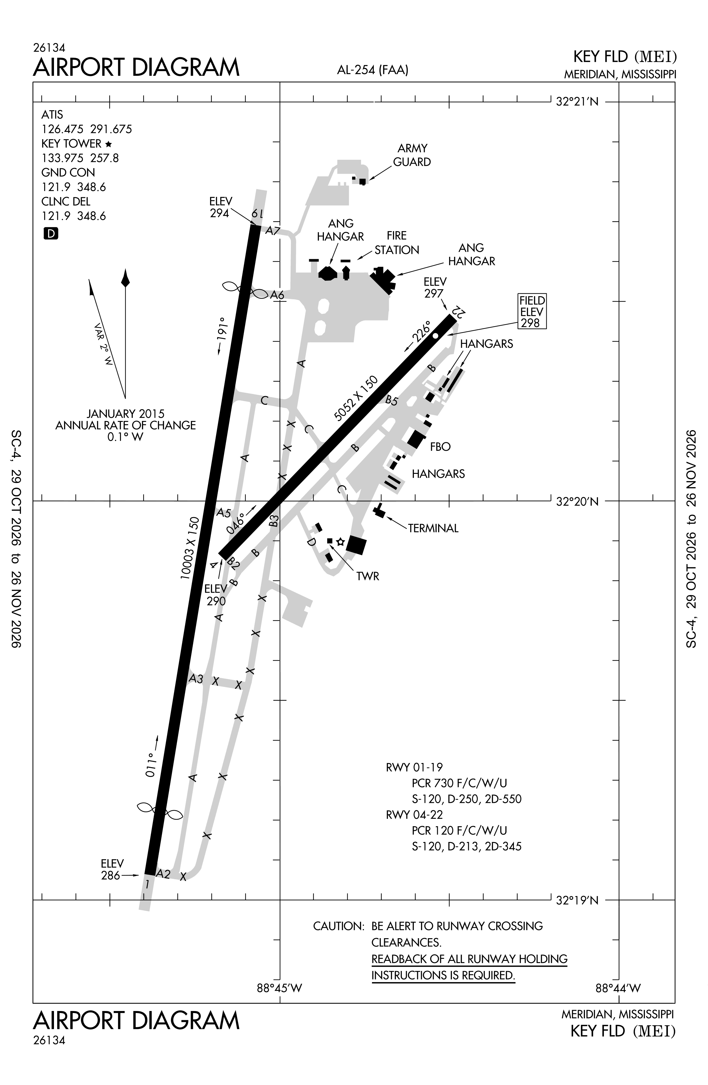
Official FAA PDF (effective Oct 29 to Nov 26)
FAA airport diagram, cycle 2611, effective Oct 29 to Nov 26, 2026. Reference only, not for navigation.
FBOs and services
FBOs
No FBOs are listed in OpenStreetMap for this airport.
Not listed? The FBO may not be in OpenStreetMap. Send a correction.
Data © OpenStreetMap contributors (ODbL), as of Nov 3, 2026.
Related
- Interactive NOTAM search for KMEI (category filters, maps, share links and a NOTAM decoder)
- Key Field: codes, map and current weather
- MEI weather and runway winds (METAR and TAF in plain English)
- Flights at MEI now
- NOTAMs for other US airports
More NOTAMs in Mississippi
Times are UTC (Z). Plain-English explanations are generated by cwsi.net from the NOTAM abbreviations and may simplify; the original NOTAM text is authoritative. NOTAMs come from the FAA NOTAM Management Service; cwsi.net refreshes its copy every 3 minutes. cwsi.net is not affiliated with the FAA: always confirm NOTAMs through official sources (a standard briefing or FAA NOTAM Search) before flight.