JST NOTAMs
John Murtha Johnstown-Cambria County Airport, Johnstown, PA · KJST
John Murtha Johnstown-Cambria County Airport in Johnstown, Pennsylvania (IATA JST, ICAO KJST) has 14 current NOTAMs (Notices to Air Missions): 14 in effect now and 0 starting later. By category: obstacles (5), procedures (5) and airspace (2). The list comes from the FAA NOTAM Management Service, refreshed by cwsi.net every few minutes; each NOTAM shows its number, category, start and end time in UTC, and a plain-English reading.
- Obstacle5
- Procedures5
- Airspace2
- Runway2
In effect now (14)
RWY 23 FICON 5/5/5 100 PCT WET OBS AT 2611050401. 2611050402-2611060402
RWY 15 FICON 5/5/5 100 PCT WET OBS AT 2611050402. 2611050402-2611060402
AIRSPACE UAS WI AN AREA DEFINED AS 1NM RADIUS OF 403043.10N0782329.20W (7.8NM NW 6G6) SFC-400FT AGL 2611042330-2611051430
OBST TOWER LGT (ASR 1287440) 401024.40N0784912.30W (8.6NM S JST) 2554.8FT (258.9FT AGL) U/S 2611021724-2703021724
OBST TOWER LGT (ASR 1024678) 401945.60N0785353.60W (3NM W JST) 2324FT (503FT AGL) U/S 2610232221-2612072221
OBST TOWER LGT (ASR 1295597) 401612.20N0785810.60W (6.8NM SW JST) 2141FT (259FT AGL) U/S 2610191018-2612031018
OBST TOWER (ASN UNKNOWN) 403650N0784218W (8.7NM NE 9G8) 2479FT (300FT AGL) NOT LGTD 2610131326-2702032359
OBST TOWER LGT (ASR 1333636) 400737.60N0791715.24W (11.1NM SSE LBE) 2139FT (209FT AGL) U/S 2609211154-2612202359
AIRSPACE UAS WI AN AREA DEFINED AS 1NM RADIUS OF 401812N0782816W (6.9NM WNW AOO) SFC-200FT AGL DLY SR-SS 2609171056-2709162321
SID JOHN MURTHA JOHNSTOWN/CAMBRIA COUNTY, JOHNSTOWN, PA. LILLI FIVE DEPARTURE... TAKEOFF MINIMUMS: RWY 15: STANDARD WITH MINIMUM CLIMB OF 221 FT/NM TO 3600. REQUIRED FOR OBSTACLE CLEARANCE. ALL OTHER DATA REMAINS AS PUBLISHED. 2607231229-2807241229EST
IAP JOHN MURTHA JOHNSTOWN/CAMBRIA COUNTY, JOHNSTOWN, PA. VOR Y RWY 15, AMDT 9B... VOR Z RWY 15, AMDT 7B... PROCEDURE NA. 2607021955-2807021955EST
ODP JOHN MURTHA JOHNSTOWN/CAMBRIA COUNTY, JOHNSTOWN, PA. TAKEOFF MINIMUMS AND (OBSTACLE) DEPARTURE PROCEDURES AMDT 4A... TAKE-OFF MINIMUMS: RWY 15, STANDARD WITH MINIMUM CLIMB OF 221 FT PER NM TO 3600. PERM WIND TURBINES UP TO 3246FT MSL BEGINNING 5.8NM SOUTHEAST OF RWY 15 (42-160875, 42-160874, 42-160877). ALL OTHER DATA REMAINS AS PUBLISHED. 2603051413-2803051412EST
IAP JOHN MURTHA JOHNSTOWN/CAMBRIA COUNTY, JOHNSTOWN, PA. ILS OR LOC RWY 33, AMDT 7C... S-ILS 33 DA 2520/HAT 239 ALL CATS.. 2602171959-2802171959EST
IAP JOHN MURTHA JOHNSTOWN/CAMBRIA COUNTY, JOHNSTOWN, PA. VOR Z RWY 23, AMDT 4B... TERMINAL ROUTES FROM JST VOR/DME TO JUDEY/JST 10.00 DME/RADAR MINIMUM ALTITUDE 4600.. 2508251637-2708271637EST
Airport diagram
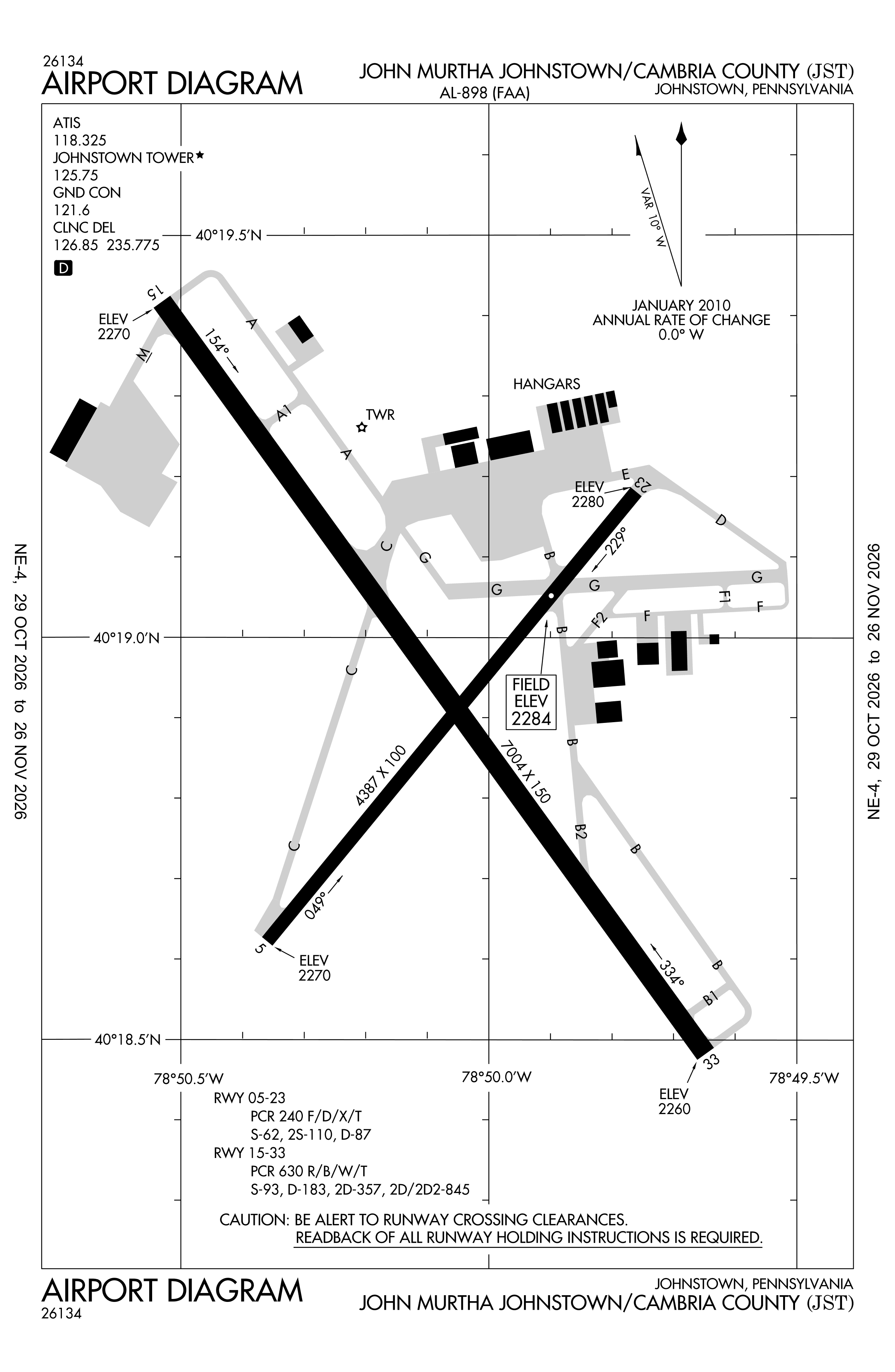
Official FAA PDF (effective Oct 29 to Nov 26)
FAA airport diagram, cycle 2611, effective Oct 29 to Nov 26, 2026. Reference only, not for navigation.
FBOs and services
FBOs
No FBOs are listed in OpenStreetMap for this airport.
Not listed? The FBO may not be in OpenStreetMap. Send a correction.
Data © OpenStreetMap contributors (ODbL), as of Nov 3, 2026.
Related
- Interactive NOTAM search for KJST (category filters, maps, share links and a NOTAM decoder)
- John Murtha Johnstown-Cambria County Airport: codes, map and current weather
- JST weather and runway winds (METAR and TAF in plain English)
- Flights at JST now
- NOTAMs for other US airports
More NOTAMs in Pennsylvania
Times are UTC (Z). Plain-English explanations are generated by cwsi.net from the NOTAM abbreviations and may simplify; the original NOTAM text is authoritative. NOTAMs come from the FAA NOTAM Management Service; cwsi.net refreshes its copy every 3 minutes. cwsi.net is not affiliated with the FAA: always confirm NOTAMs through official sources (a standard briefing or FAA NOTAM Search) before flight.