JMS NOTAMs
Jamestown Regional Airport, Jamestown, ND · KJMS
Jamestown Regional Airport in Jamestown, North Dakota (IATA JMS, ICAO KJMS) has 13 current NOTAMs (Notices to Air Missions): 13 in effect now and 0 starting later. By category: obstacles (8), aerodromes (3) and aprons (1). The list comes from the FAA NOTAM Management Service, refreshed by cwsi.net every few minutes; each NOTAM shows its number, category, start and end time in UTC, and a plain-English reading.
- Obstacle8
- Aerodrome3
- Apron1
- Procedures1
In effect now (13)
AD AP WIND TEE LGT U/S 2611051132-2611121500EST
AD AP ABN NOT STD 2611051130-2611201130
APRON TERMINAL RAMP WIP HVY EQPT WORK NEXT TO TERMINAL BARRICADED 2611031731-2611062200
OBST TOWER LGT (ASR 1024696) 465004.70N0984134.50W (5.7NM S JMS) 1786.1FT (305.1FT AGL) U/S 2611030750-2611180650
OBST TOWER LGT (ASR 1219536) 465353.80N0983336.10W (5.2NM E JMS) 1728FT (317FT AGL) U/S 2610271430-2612112030
OBST TOWER LGT (ASR 1228271) 465322.10N0985923.90W (13.0NM W JMS) 2082.0FT (344.2FT AGL) U/S 2610271350-2611111250
OBST TOWER LGT (ASN 2021-AGL-15257-OE) 464723N0983520W (9.2NM SSE JMS) 1906FT (415FT AGL) U/S 2610120431-2611112300
OBST TOWER LGT (ASR 1048883) 465525.50N0984620.50W (3.9NM W JMS) 1993FT (499FT AGL) U/S 2610101027-2611241027
OBST TOWER LGT (ASR 1011854) 470538.00N0990212.00W (17.7NM NW JMS) 2601.7FT (702.1FT AGL) U/S 2609170052-2611162359
OBST TOWER LGT (ASR 1206988) 465415.50N0984359.60W (2.7NM SW JMS) 1698.8FT (215.9FT AGL) U/S 2609030043-2612020143
OBST TOWER LGT (ASR 1250936) 470917.80N0983203.30W (14.7NM NNE JMS) 1842.8FT (298.9FT AGL) U/S 2609012016-2611302116
AD AP SFC COND NOT REP DLY 0100-1300 2605010100-2704281300
IAP JAMESTOWN RGNL, JAMESTOWN, ND. VOR RWY 31, AMDT 9A... S-31 MDA 2220/HAT 722, VIS CAT C/D 1 5/8. CIRCLING CAT A/B/C MDA 2220/HAA 720, CAT C VIS 2. AMUJO FIX ALTITUDE 2220. WHEN LOCAL ALTIMETER SETTING NOT RECEIVED, USE BAC ALTIMETER SETTING: INCREASE ALL MDAS 80 FEET AND S-31 VISIBILITY CAT B/C/D 1/4 SM, AND CIRCLING VISIBILITY CAT B/C/D 1/2 SM; INCREASE AMUJO FIX MINIMUMS VISIBILITY CAT C/D 1/4 SM, AND CIRCLING VISIBILITY CAT B/C/D 1/2 SM. 2512082137-2712082137EST
Airport diagram
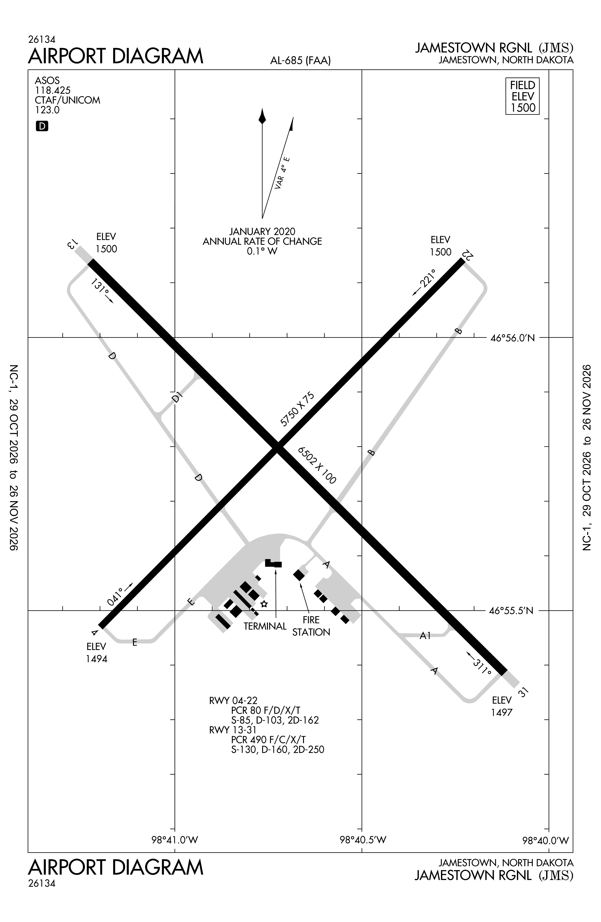
Official FAA PDF (effective Oct 29 to Nov 26)
FAA airport diagram, cycle 2611, effective Oct 29 to Nov 26, 2026. Reference only, not for navigation.
FBOs and services
FBOs
No FBOs are listed in OpenStreetMap for this airport.
Not listed? The FBO may not be in OpenStreetMap. Send a correction.
Data © OpenStreetMap contributors (ODbL), as of Nov 3, 2026.
Related
- Interactive NOTAM search for KJMS (category filters, maps, share links and a NOTAM decoder)
- Jamestown Regional Airport: codes, map and current weather
- JMS weather and runway winds (METAR and TAF in plain English)
- Flights at JMS now
- NOTAMs for other US airports
More NOTAMs in North Dakota
Times are UTC (Z). Plain-English explanations are generated by cwsi.net from the NOTAM abbreviations and may simplify; the original NOTAM text is authoritative. NOTAMs come from the FAA NOTAM Management Service; cwsi.net refreshes its copy every 3 minutes. cwsi.net is not affiliated with the FAA: always confirm NOTAMs through official sources (a standard briefing or FAA NOTAM Search) before flight.