HYA NOTAMs
Cape Cod Gateway Airport, Hyannis, MA · KHYA
Cape Cod Gateway Airport in Hyannis, Massachusetts (IATA HYA, ICAO KHYA) has 14 current NOTAMs (Notices to Air Missions): 14 in effect now and 0 starting later. By category: obstacles (7), taxiways (3) and procedures (2). The list comes from the FAA NOTAM Management Service, refreshed by cwsi.net every few minutes; each NOTAM shows its number, category, start and end time in UTC, and a plain-English reading.
- Obstacle7
- Taxiway3
- Procedures2
- Aerodrome1
- Runway1
In effect now (14)
OBST CRANE (ASN 2025-ANE-328-OE) 414016N0701741W (0.6NM W HYA) 172FT (120FT AGL) FLAGGED 2611051312-2611052000EST
OBST CRANE (ASN 2025-ANE-857-OE) 413945N0701334W (2.4NM E HYA) 230FT (210FT AGL) FLAGGED 2611021131-2611062300
OBST CRANE (ASN 2025-ANE-3450-OE) 413958N0701811W (1.0NM W HYA) 178FT (120FT AGL) FLAGGED 2611021131-2611062300
IAP CAPE COD GATEWAY, HYANNIS, MA. ILS OR LOC RWY 24, AMDT 19B... ALTERNATE MINIMUMS NA EXCEPT FOR ACFT EQUIPPED WITH SUITABLE RNAV SYSTEM WITH GPS, ACK VOR/DME UNMONITORED. 2611011252-2611202359EST
IAP CAPE COD GATEWAY, HYANNIS, MA. ILS OR LOC RWY 15, AMDT 5C... ILS OR LOC RWY 24, AMDT 19B... MSA FROM MVY VOR/DME 25NM 270 CW 360 MINIMUM ALTITUDE 2100, 360 CW 270 MINIMUM ALTITUDE 1900. (PERM OBST 2020-WTE-6308-OE). 2610291435-2706011615EST
OBST TOWER LGT (ASR 1234471) 414130.50N0700847.80W (6.1NM ENE HYA) 294.9FT (250.0FT AGL) U/S 2610280434-2611112359
TWY E SFC PAINTED HLDG PSN SIGNS AT RWY 33/15 NOT STD 2610171653-2705311900EST
RWY 06 PAPI U/S 2610171655-2711301900
AD AP WINDCONE PRI LGT U/S 2610171655-2705312000EST
TWY D EDGE LGT BTN RWY 06/24 AND TWY B U/S 2610171654-2705312000EST
TWY B EDGE LGT U/S 2610171654-2705312000EST
OBST TOWER LGT (ASR 1004090) 414126.00N0701119.00W (4.3NM ENE HYA) 350.7FT (320.9FT AGL) U/S 2609032004-2612022104
OBST TOWER LGT (ASR 1007750) 414344.50N0700959.90W (6.3NM NE HYA) 422.9FT (362.9FT AGL) U/S 2608252013-2611232113
OBST CRANE (ASN UNKNOWN) 414202N0701856 (2NM N HYA) 229FT (141FT AGL) FLAGGED, NOT LGTD MON TUE 1100-1900 2607201100-2611151900
Airport diagram
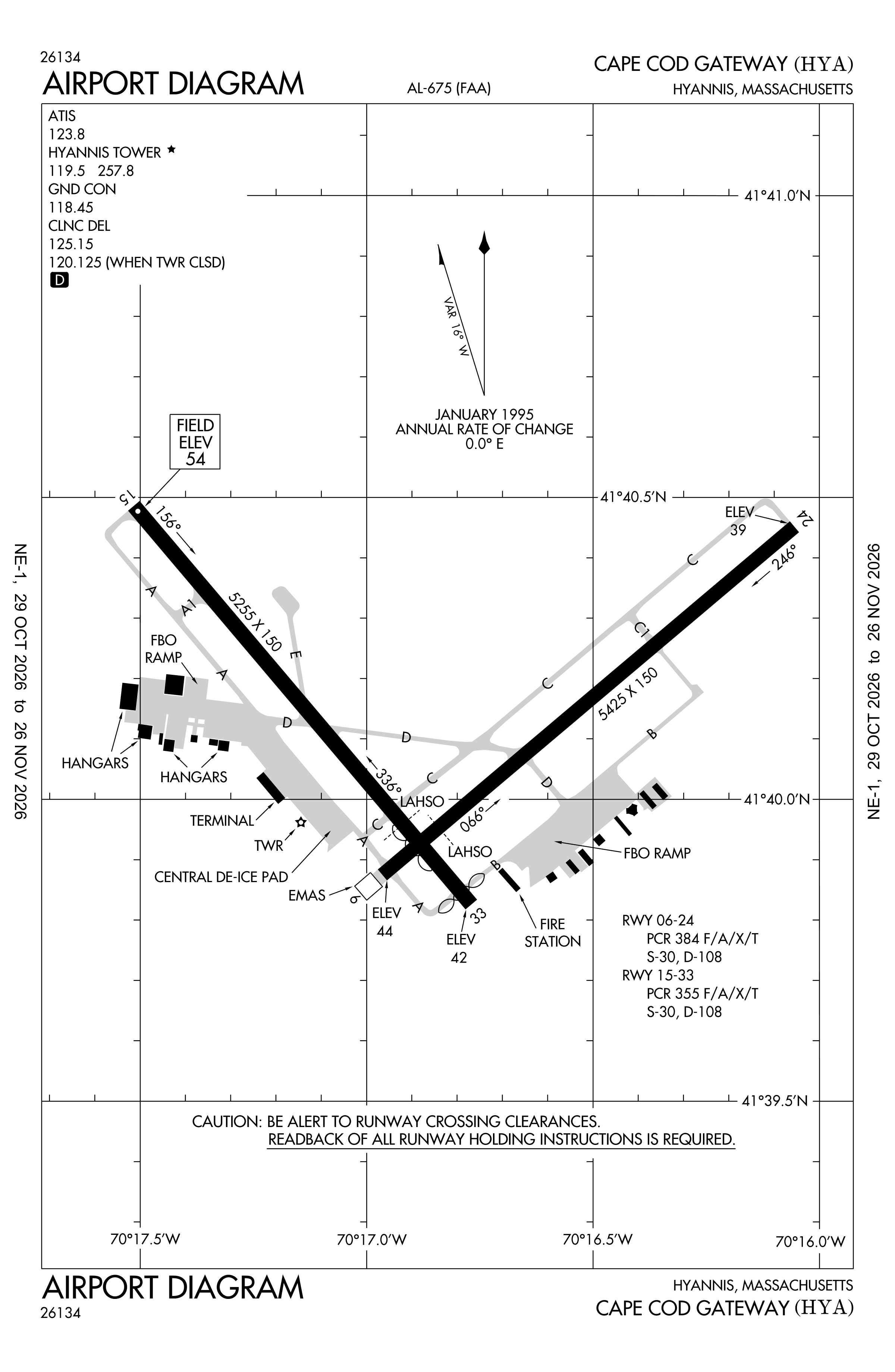
Official FAA PDF (effective Oct 29 to Nov 26)
FAA airport diagram, cycle 2611, effective Oct 29 to Nov 26, 2026. Reference only, not for navigation.
FBOs and services
FBOs
 Atlantic Aviation Hyannis730 Barnstable Road, Hyannis, MA+1 508-771-7520Hours: Mon-Sun: 0600-1800 On-call services with prior arrangementsAtlantic pageSource: Atlantic Aviation
FBO locations from the operators' own sites, may be out of date. Call ahead to confirm services and hours.
Not listed? The FBO may not be in OpenStreetMap. Send a correction.
Atlantic Aviation locations, as of Nov 5, 2026.
Related
- Interactive NOTAM search for KHYA (category filters, maps, share links and a NOTAM decoder)
- Cape Cod Gateway Airport: codes, map and current weather
- HYA weather and runway winds (METAR and TAF in plain English)
- Flights at HYA now
- NOTAMs for other US airports
More NOTAMs in Massachusetts
Times are UTC (Z). Plain-English explanations are generated by cwsi.net from the NOTAM abbreviations and may simplify; the original NOTAM text is authoritative. NOTAMs come from the FAA NOTAM Management Service; cwsi.net refreshes its copy every 3 minutes. cwsi.net is not affiliated with the FAA: always confirm NOTAMs through official sources (a standard briefing or FAA NOTAM Search) before flight.