HOM NOTAMs
Homer Airport, Homer, AK · PAHO
Homer Airport in Homer, Alaska (IATA HOM, ICAO PAHO) has 14 current NOTAMs (Notices to Air Missions): 14 in effect now and 0 starting later. By category: procedures (5), runways (2) and aerodromes (1). The list comes from the FAA NOTAM Management Service, refreshed by cwsi.net every few minutes; each NOTAM shows its number, category, start and end time in UTC, and a plain-English reading.
- Procedures5
- Runway2
- Aerodrome1
- Apron1
- Communications1
- Obstacle1
- Services1
- Taxiway1
- Other1
In effect now (14)
APRON ALL FICON WET OBS AT 2611041709. 2611041709-2611051709
TWY ALL FICON WET OBS AT 2611041707. 2611041707-2611051707
RWY 04 FICON 5/5/5 100 PCT WET OBS AT 2611041704. 2611041704-2611051704
OBST CRANE (ASN UNKNOWN) 593816N1513007W (0.5NM SW PAHO) 90FT (90FT AGL) FLAGGED, LGTD 2611022042-2611110300
COM REMOTE COM OUTLET 122.2 U/S 2610300530-2611281400EST
RWY 04 PAPI U/S 2610250412-2611291500EST
AD AP ABN OBST LGT U/S 2610121648-2612312359
SVC AUTOMATED SURFACE OBSERVING SYSTEM TEL CHANGED TO 907-202-8234 2609021437-PERM
IAP HOMER, HOMER, AK. RNAV (GPS) Y RWY 4, AMDT 1D... ADD NOTE: 34:1 IS NOT CLEAR. 2607201753-2807202355EST
A1285/25 NOTAMN Q) PAZA/QNBAW/IV/BO/AE/000/999/ A) PAHO B) 2510291611 C) PERM E) /ACE/ NAV NDB DECOMMISSIONED
IAP HOMER, HOMER, AK. LOC RWY 4, AMDT 12... PROCEDURE NA. 2510021827-2710021827EST
IAP HOMER, HOMER, AK. LOC BC RWY 22, AMDT 7... LOC RWY 4, AMDT 12... RNAV (GPS) Y RWY 4, AMDT 1D... DISREGARD NOTE: CIRCLING NA TO WATERWAYS 6W AND 24W. 2510021231-2707311230EST
IAP HOMER, HOMER, AK. RNAV (GPS) Y RWY 22, AMDT 1C... RWY 22 HELICOPTER VISIBILITY REDUCTION BELOW 3/4 SM NOT AUTHORIZED. DISREGARD NOTE: CIRCLING NA TO WATERWAYS 6W AND 24W. 2507311500-2707311459EST
IAP HOMER, HOMER, AK. RNAV (GPS) Z RWY 4, AMDT 1D... ADD NOTE: 34:1 IS NOT CLEAR. 2502201101-2702201101EST
Airport diagram
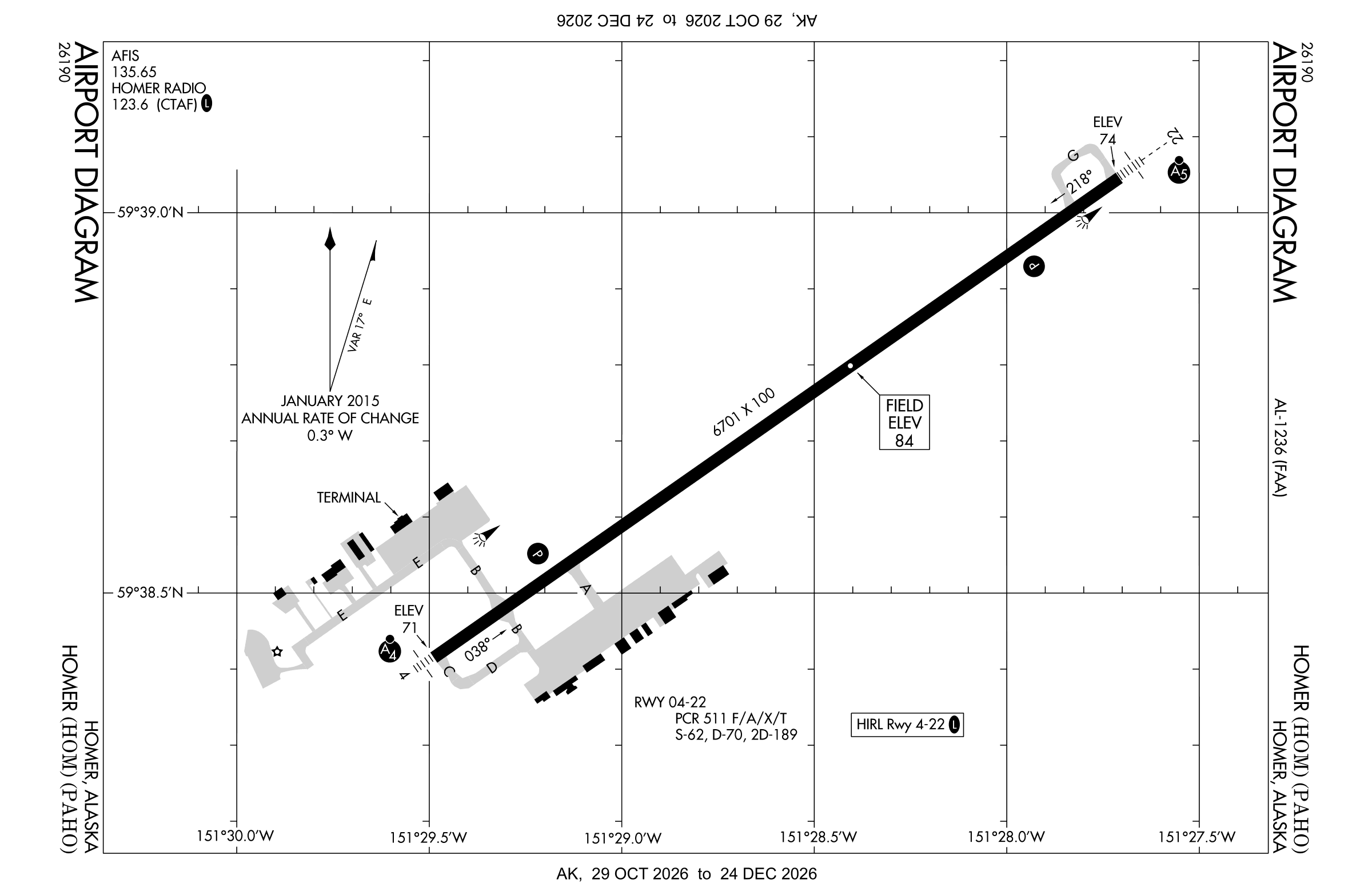
Official FAA PDF (effective Oct 29 to Nov 26)
FAA airport diagram, cycle 2611, effective Oct 29 to Nov 26, 2026. Reference only, not for navigation.
FBOs and services
FBOs
No FBOs are listed in OpenStreetMap for this airport.
Not listed? The FBO may not be in OpenStreetMap. Send a correction.
Data © OpenStreetMap contributors (ODbL), as of Nov 3, 2026.
Related
- Interactive NOTAM search for PAHO (category filters, maps, share links and a NOTAM decoder)
- Homer Airport: codes, map and current weather
- HOM weather and runway winds (METAR and TAF in plain English)
- Flights at HOM now
- NOTAMs for other US airports
More NOTAMs in Alaska
Times are UTC (Z). Plain-English explanations are generated by cwsi.net from the NOTAM abbreviations and may simplify; the original NOTAM text is authoritative. NOTAMs come from the FAA NOTAM Management Service; cwsi.net refreshes its copy every 3 minutes. cwsi.net is not affiliated with the FAA: always confirm NOTAMs through official sources (a standard briefing or FAA NOTAM Search) before flight.