DAY NOTAMs
James M. Cox Dayton International Airport, Dayton, OH · KDAY
James M. Cox Dayton International Airport in Dayton, Ohio (IATA DAY, ICAO KDAY) has 30 current NOTAMs (Notices to Air Missions): 24 in effect now and 6 starting later. By category: taxiways (10), navaids (7) and runways (5). The list comes from the FAA NOTAM Management Service, refreshed by cwsi.net every few minutes; each NOTAM shows its number, category, start and end time in UTC, and a plain-English reading.
- Taxiway10
- Navaid7
- Runway5
- Apron4
- Obstacle2
- Procedures2
In effect now (24)
RWY 24L ALS U/S EXC HIGH INTST ON CONS 2611170113-2612032000EST
APRON TERMINAL APN BTN GATE B12 AND GATE B14 CLSD AND BARRICADED 2611151457-2612042300
OBST TOWER LGT (ASR 1063569) 395415.40N0841125.60W (1.3NM E DAY) 1103.0FT (140.1FT AGL) U/S 2611101518-2702081518
OBST TOWER LGT (ASR 1234070) 395211.50N0840655.80W (5.1NM ESE DAY) 1296.9FT (306.1FT AGL) U/S 2611090604-2611240504
IAP JAMES M COX DAYTON INTL, DAYTON, OH. ILS RWY 6L (CAT II-III), AMDT 10 ... S-ILS 6L CAT II NA EXCEPT FOR AIRCRAFT EQUIPPED WITH RADIO ALTIMETER. I-ATD IM OUT OF SERVICE. 2611061730-2706181730EST
RWY 24L RAI LGT U/S 2611060927-2611202000EST
TWY D, H HLDG PSN SIGN FOR RWY 24L LGT U/S 2611060456-2612010500
TWY D, H, L EDGE LGT U/S 2611060445-2612010500
TWY H HLDG PSN SIGN FOR ILS FOR RWY 24L LGT U/S 2611050925-2611302300
TWY H HLDG PSN SIGN FOR RWY36 LGT U/S 2611050924-2611302300
RWY 24R DIST REMAINING SIGN MISSING 2611021138-2612312300
APRON TERMINAL APN BTN GATE A15 AND GATE A23 CLSD BARRICADED 2611012251-2611202300
TWY W EDGE LGT U/S 2611011111-2612312300
TWY D HLDG PSN SIGN FOR APCH END RWY 36 LGT U/S 2610311110-2611302300
TWY D HLDG PSN SIGN LGT U/S 2610311109-2611302300
RWY 36 PAPI U/S 2610291832-2701152000EST
APRON TERMINAL APN BTN GATE A22 AND GATE A25 CLSD BARRICADED 2610220619-2611262300
NAV ILS RWY 06L OM U/S 2606041637-2801242111EST
NAV ILS RWY 06L IM U/S 2606041636-2801242111EST
SID JAMES M COX DAYTON INTL, DAYTON, OH. DAYTON NINE DEPARTURE... DISREGARD TOP ALTITUDE: 5000. TOP ALTITUDE: AS ASSIGNED BY ATC. CHANGE DEPARTURE ROUTE DESCRIPTION TO READ: ....FOR RADAR VECTORS TO FILED ROUTE, MAINTAIN ALTITUDE ASSIGNED BY ATC, EXPECT REQUESTED ALTITUDE 10 MINUTES AFTER DEPARTURE. ALL OTHER DATA REMAINS AS PUBLISHED. 2605281342-2805271337EST
TWY W HLDG PSN SIGN FOR APCH END RWY 06L LGT U/S 2603292205-2612312300
APRON HOLD PAD FOR RWY 06L CLSD DLY 0300-1100 2505230300-2612311100
TWY W HLDG PSN SIGN FOR ILS FOR APCH END RWY 06L LGT U/S 2504181355-2612312200EST
TWY W HLDG PSN SIGN FOR TWY M LGT U/S 2504181352-2612312200EST
Starting later (6)
NAV ILS RWY 06L BRUNY LOM NOT MNT 2611180500-2611181100
NAV ILS RWY 24L LOC NOT MNT 2611180500-2611181100
NAV ILS RWY 06L BRUNY LOM NOT MNT 2611170600-2611171200
NAV ILS RWY 06L LOC/IM NOT MNT 2611170600-2611171200
NAV ILS RWY 18 U/S 2611171330-2611172100
RWY 06L/24R CLSD 2611171300-2611171700
Airport diagram

FAA chart (PNG) Official FAA PDF (effective Oct 29 to Nov 26)
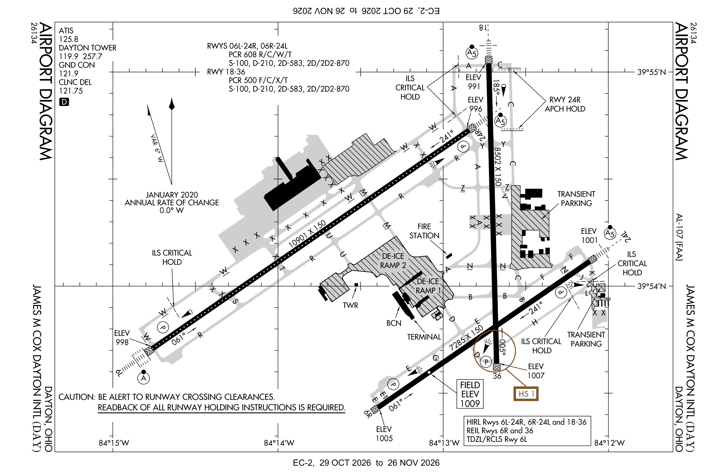
Redrawn by cwsi.net from the FAA airport diagram, cycle 2611, effective Oct 29 to Nov 26, 2026, and OpenStreetMap. Reference only, not for navigation.
FBOs and services
FBOs
- Premier FBO+1 937-454-3400premierprivatejets.com
FBO details may be out of date. Call ahead to confirm services and hours.
Not listed? Send a correction.
As of Nov 3, 2026.
Related
- Interactive NOTAM search for KDAY (category filters, maps, share links and a NOTAM decoder)
- James M. Cox Dayton International Airport: codes, map and current weather
- DAY weather and runway winds (METAR and TAF in plain English)
- Flights at DAY now
- NOTAMs for other US airports
More NOTAMs in Ohio
Times are UTC (Z). Plain-English explanations are generated by cwsi.net from the NOTAM abbreviations and may simplify; the original NOTAM text is authoritative. NOTAMs come from the FAA NOTAM Management Service; cwsi.net refreshes its copy every 3 minutes. cwsi.net is not affiliated with the FAA: always confirm NOTAMs through official sources (a standard briefing or FAA NOTAM Search) before flight.