CRW NOTAMs
West Virginia International Yeager Airport, Charleston, WV · KCRW
West Virginia International Yeager Airport in Charleston, West Virginia (IATA CRW, ICAO KCRW) has 32 current NOTAMs (Notices to Air Missions): 30 in effect now and 2 starting later. By category: obstacles (16), runways (7) and taxiways (3). The list comes from the FAA NOTAM Management Service, refreshed by cwsi.net every few minutes; each NOTAM shows its number, category, start and end time in UTC, and a plain-English reading.
- Obstacle16
- Runway7
- Taxiway3
- Communications1
- Procedures1
- Other4
In effect now (30)
RWY 23 FICON 5/5/5 100 PCT WET OBS AT 2611051243. 2611051243-2611061243
RWY 23 FICON 5/5/5 100 PCT WET OBS AT 2611050442. 2611050442-2611060442
RWY 23 FICON 5/5/5 100 PCT WET OBS AT 2611050154. 2611050154-2611060154
RWY 23 FICON 5/5/5 100 PCT WET OBS AT 2611050018. 2611050018-2611060018
RWY 23 FICON 5/5/5 100 PCT WET OBS AT 2611042139. 2611042139-2611052139
RWY 23 FICON 5/5/5 100 PCT WET OBS AT 2611041931. 2611041931-2611051931
RWY 23 FICON 5/5/5 100 PCT WET OBS AT 2611041537. 2611041537-2611051537
M0187/26 NOTAMN Q) ZID/QFAAM/IV/NBO/A/000/999/3822N08135W005 A) KCRW B) 2611032100 C) 2611061300 E) AERODROME USAF ARFF CLS FOR MANNING FOR AF VEH SET 3 DAILY FROM 2100-1300
TWY D CLSD 2610301240-2611302300
COM REMOTE COM OUTLET 122.2 U/S 2610291135-2611302000EST
M0183/26 NOTAMN Q) ZID/QFAAM/IV/NBO/A/000/999/3822N08135W005 A) KCRW B) 2611022000 C) 2612312000 E) AERODROME USAF ARFF RLS FOR AF VEH SET 3
OBST TOWER LGT (ASR 1310494) 380713.50N0813626.30W (15.3NM S CRW) 1800FT (307FT AGL) U/S 2610270012-2612110612
OBST TOWER LGT (ASR 1034650) 381656.00N0812931.00W (7.3NM SE CRW) 1913.1FT (313.0FT AGL) U/S 2610210625-2611242359
OBST TOWER LGT (ASR 1212849) 383408.80N0813800.90W (11.8NM N CRW) 1135.2FT (325.1FT AGL) U/S 2610150033-2701130133
TWY D BTN TWY C2 AND TWY C3 CLSD BARRICADED CLSD 2610132024-2701012359
OBST TOWER LGT (ASR 1054161) 382155.00N0814613.00W (8.4NM W CRW) 1306.1FT (427.8FT AGL) U/S 2610131858-2702132359
OBST TOWER LGT (ASR 1036503) 382353.00N0814105.00W (4.5NM WNW CRW) 1432.7FT (303.8FT AGL) U/S 2610131857-2702132359
OBST TOWER LGT (ASR 1054160) 382154.00N0814605.00W (8.3NM W CRW) 1376.0FT (427.8FT AGL) U/S 2610131857-2702132359
OBST TOWER LGT (ASR 1054157) 381906.00N0813226.00W (4.2NM SE CRW) 1450.5FT (307.1FT AGL) U/S 2610131856-2702132359
OBST TOWER LGT (ASR 1035665) 381314.00N0812452.00W (12.5NM SE CRW) 1910.4FT (330.1FT AGL) U/S 2610101226-2611092300
OBST TOWER LGT (ASR 1216448) 382923.60N0812606.40W (10.2NM NE CRW) 1482.9FT (303.8FT AGL) U/S 2609211250-2612201350
TWY C IN PAVEMENT RWY GUARD LGT NOT STD 2609051408-2612312200
OBST TOWER LGT (ASR 1212641) 382359.80N0814420.20W (7.0NM WNW CRW) 1308.1FT (269.0FT AGL) U/S 2609050729-2701030729
OBST TOWER LGT (ASR 1223501) 381626.00N0814938.00W (12.7NM WSW CRW) 1152.6FT (237.9FT AGL) U/S 2609030008-2612020108
OBST TOWER LGT (ASR 1238159) 382234.60N0813923.50W (3.0NM W CRW) 1290.0FT (330.1FT AGL) U/S 2608241754-2612312359
OBST TOWER LGT (ASR 1033441) 382511.00N0814323.00W (6.6NM WNW CRW) 1318.9FT (219.8FT AGL) U/S 2608181534-2611182359
OBST TOWER LGT (ASR 1244516) 380924.20N0815052.80W (18.0NM SW CRW) 1458.7FT (298.9FT AGL) U/S 2608112132-2612092132
IAP WEST VIRGINIA INTL YEAGER, CHARLESTON, WV. ILS OR LOC RWY 23, AMDT 31A... NOTE: AUTOPILOT COUPLED APPROACH NA BELOW 1500. 2511181612-2711181612EST
OBST PARKED ACFT (ASN 2020-AEA-1586-NRA) 382227N0813533W (0.1NM S CRW) 975FT (38FT AGL) LGTD 2401111826-2901112359
OBST PARKED ACFT (ASN 2020-AEA-1585-NRA) 382225N0813537W (0.2NM S CRW) 978FT (38FT AGL) LGTD 2401111825-2901112359
Starting later (2)
M0189/26 NOTAMN Q) ZID/QFAAM/IV/NBO/A/000/999/3822N08135W005 A) KCRW B) 2611090500 C) 2611101300 E) AERODROME USAF ARFF CLS FOR MANNING FOR AF VEH SET 3
M0188/26 NOTAMN Q) ZID/QFAAM/IV/NBO/A/000/999/3822N08135W005 A) KCRW B) 2611062100 C) 2611070500 E) AERODROME USAF ARFF CLS FOR MANNING FOR AF VEH SET 3
Airport diagram
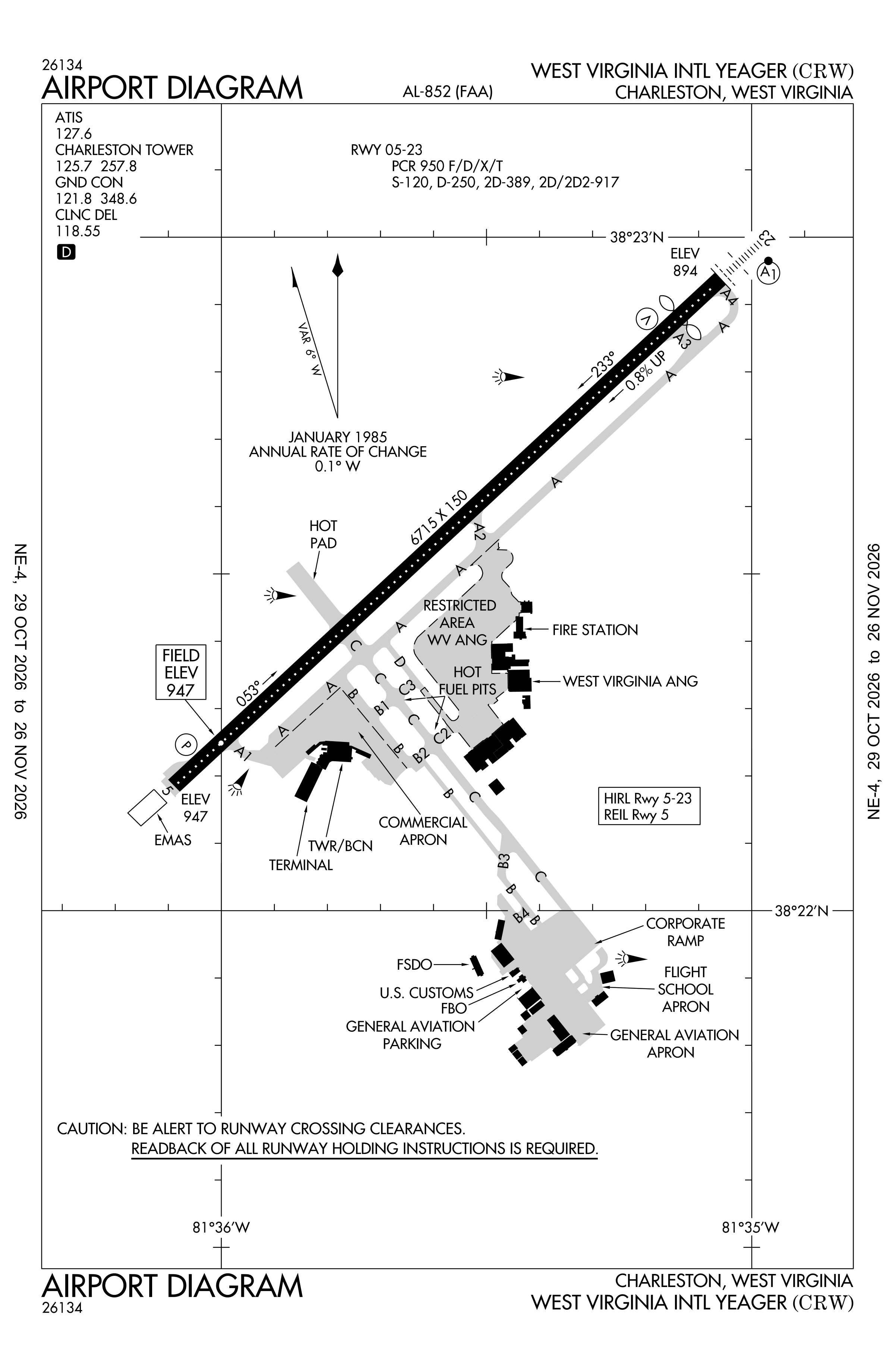
Official FAA PDF (effective Oct 29 to Nov 26)
FAA airport diagram, cycle 2611, effective Oct 29 to Nov 26, 2026. Reference only, not for navigation.
FBOs and services
FBOs
No FBOs are listed in OpenStreetMap for this airport.
Not listed? The FBO may not be in OpenStreetMap. Send a correction.
Data © OpenStreetMap contributors (ODbL), as of Nov 3, 2026.
Related
- Interactive NOTAM search for KCRW (category filters, maps, share links and a NOTAM decoder)
- West Virginia International Yeager Airport: codes, map and current weather
- CRW weather and runway winds (METAR and TAF in plain English)
- Flights at CRW now
- NOTAMs for other US airports
More NOTAMs in West Virginia
Times are UTC (Z). Plain-English explanations are generated by cwsi.net from the NOTAM abbreviations and may simplify; the original NOTAM text is authoritative. NOTAMs come from the FAA NOTAM Management Service; cwsi.net refreshes its copy every 3 minutes. cwsi.net is not affiliated with the FAA: always confirm NOTAMs through official sources (a standard briefing or FAA NOTAM Search) before flight.