BFI NOTAMs
King County International Airport-Boeing Field, Seattle, WA · KBFI
King County International Airport-Boeing Field in Seattle, Washington (IATA BFI, ICAO KBFI) has 25 current NOTAMs (Notices to Air Missions): 25 in effect now and 0 starting later. By category: runways (7), communications (5) and taxiways (5). The list comes from the FAA NOTAM Management Service, refreshed by cwsi.net every few minutes; each NOTAM shows its number, category, start and end time in UTC, and a plain-English reading.
- Runway7
- Communications5
- Taxiway5
- Navaid4
- Obstacle2
- Procedures1
- Services1
In effect now (25)
NAV ILS RWY 32L U/S 2611050330-2611092000EST
NAV ILS RWY 14R U/S 2611050330-2611092000EST
SVC TEMPO TWR LOCAL CTL 120.6, GND CTL 121.9, CTC GRD FOR CLR DELIVERY 2611050259-2612042359
NAV ILS RWY 32L NOT MNT 2611050200-2612042359
NAV ILS RWY 14R NOT MNT 2611050200-2612042359
COM REMOTE TRANS/REC 118.3, 257.8 U/S 2611050200-2612042359
COM REMOTE TRANS/REC 126.55 U/S 2611050200-2612042359
COM REMOTE TRANS/REC 125.9 U/S 2611041647-2611182000EST
COM REMOTE TRANS/REC 125.9 U/S 2611041631-2611182000EST
RWY 14R/32L CL MARKINGS OBSC 2611021735-2705310759
TWY A5 BTN RWY 14L/32R AND TWY A NORTHEAST SIDE IRREGULAR SFC 2611021729-2705312359
TWY B7 NORTH EDGE IRREGULAR SFC 2611021729-2705310759
TWY A1 HLDG PSN MARKINGS FOR ILS NOT STD 2611021727-2705310759
TWY A1, B1 LOCATION MARKINGS NOT STD 2611021728-2705310759
COM REMOTE TRANS/REC 125.9 U/S 2611021634-2611132000EST
TWY B BTN TWY B4 AND TWY B5 WIP CONST ADJ WEST EDGE LGTD AND BARRICADED 2611021401-2612010759
RWY 14L/32R BTN TWY A4 AND TWY A5 IRREGULAR SFC NOT GROOVED 2610310309-2611272330
RWY 14L/32R BTN TWY A4 AND TWY A5 CL MARKING NOT GROOVED 2610310300-2611272330
RWY 14L PAPI U/S 2608202052-2612310759
RWY 14R/32L E SIDE IRREGULAR SFC 2607301458-2612310759
RWY 32L TDZ SFC MARKING NOT STD LEFT SIDE 2606241559-2612312330
RWY 14L/32R W EDGE IRREGULAR SFC 2605211549-2612312359
OBST CRANE (ASN 2025-ANM-4111-NRA) 473214N1221855W (0.7NM NW BFI) 215FT (199FT AGL) FLAGGED AND LGTD MON-SAT 1300-0100 2603161300-2710020100
OBST BLDG (ASN 2025-ANM-2-NRA) 473226N1221853W (0.8NM NW BFI) 32FT (22FT AGL) ERECTED 2505031741-PERM
ODP BOEING FLD/KING COUNTY INTL, SEATTLE, WA. TAKEOFF MINIMUMS AND (OBSTACLE) DEPARTURE PROCEDURES AMDT 8... TAKEOFF MINIMUMS: RWY 14L, 600-2 3/4 WITH A MINIMUM CLIMB OF 320 FT PER NM TO 600 OR STANDARD WITH A MINIMUM CLIMB OF 708 FT PER NM TO 600 OR 1000-3 FOR VCOA. ALL OTHER DATA REMAINS AS PUBLISHED. 2412201235-2612201235EST
Airport diagram
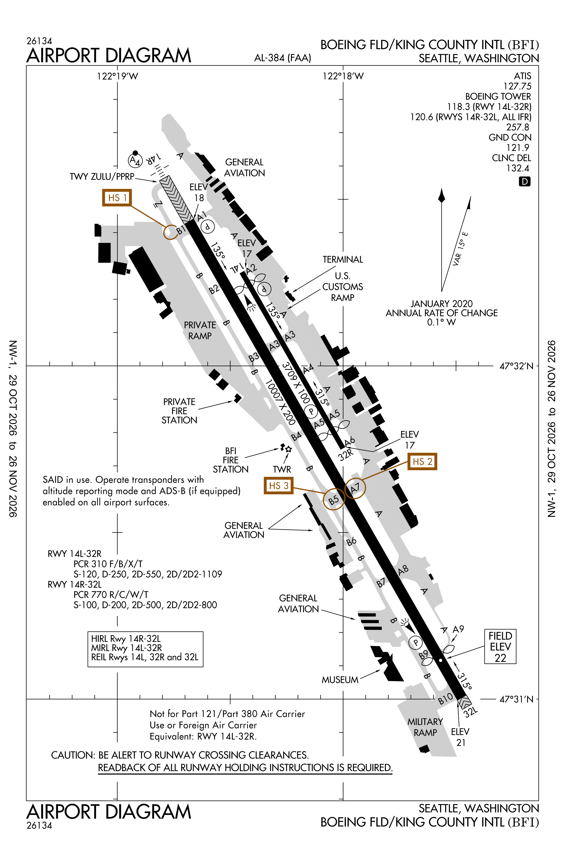
Official FAA PDF (effective Oct 29 to Nov 26)
FAA airport diagram, cycle 2611, effective Oct 29 to Nov 26, 2026. Reference only, not for navigation.
FBOs and services
FBOs
 Signature Seattle Boeing Field7149 Perimeter Road, Seattle, WA 98108+1 206-763-0350Hours: 24 hours a day M-F0600L - 2200L Sa-SuARINC 129.025Signature pageSource: Signature Aviation
- Clay Lacy AviationBrand website
- Elite Aviation
- Modern AviationBrand website
- SkyserviceBrand website
FBO locations from OpenStreetMap and the operators' own sites, community-maintained or operator-published and may be out of date. Call ahead to confirm services and hours.
Not listed? The FBO may not be in OpenStreetMap. Send a correction.
Data © OpenStreetMap contributors (ODbL), as of Nov 3, 2026; Signature Aviation locations, as of Nov 5, 2026.
Related
- Interactive NOTAM search for KBFI (category filters, maps, share links and a NOTAM decoder)
- King County International Airport-Boeing Field: codes, map and current weather
- BFI weather and runway winds (METAR and TAF in plain English)
- Flights at BFI now
- NOTAMs for other US airports
More NOTAMs in Washington
Times are UTC (Z). Plain-English explanations are generated by cwsi.net from the NOTAM abbreviations and may simplify; the original NOTAM text is authoritative. NOTAMs come from the FAA NOTAM Management Service; cwsi.net refreshes its copy every 3 minutes. cwsi.net is not affiliated with the FAA: always confirm NOTAMs through official sources (a standard briefing or FAA NOTAM Search) before flight.