AVL NOTAMs
Asheville Regional Airport, Asheville, NC · KAVL
Asheville Regional Airport in Asheville, North Carolina (IATA AVL, ICAO KAVL) has 17 current NOTAMs (Notices to Air Missions): 16 in effect now and 1 starting later. By category: obstacles (7), taxiways (4) and navaids (3). The list comes from the FAA NOTAM Management Service, refreshed by cwsi.net every few minutes; each NOTAM shows its number, category, start and end time in UTC, and a plain-English reading.
- Obstacle7
- Taxiway4
- Navaid3
- Procedures2
- Services1
In effect now (16)
TWY A7, A8 EDGE MARKINGS NOT STD 2611161930-2611302200
TWY A7, A8 CL MARKINGS NOT STD 2611161929-2611302200
NAV ILS RWY 17 GP NOT MNT 2611101801-2612302359EST
NAV ILS RWY 35 GP NOT MNT 2610281032-2612302359
OBST TOWER LGT (ASR 1019293) 353248.00N0822814.00W (7.5NM NE AVL) 2561FT (241FT AGL) U/S 2610270958-2612111058
OBST TOWER LGT (ASR 1025502) 353405.10N0823303.20W (7.9NM N AVL) 2328.7FT (214.9FT AGL) U/S 2610221149-2701200400
TWY E CLSD TO ACFT WINGSPAN MORE THAN 80FT 2610201633-2703311600
OBST TOWER LGT (ASR 1005391) 352146.40N0823322.40W (4.5NM S AVL) 2422.6FT (285.4FT AGL) U/S 2610051144-2701030400
OBST TOWER LGT (ASR 1000094) 353531.50N0823350.30W (9.4NM N AVL) 2302.5FT (163.7FT AGL) U/S 2610030440-2701010540
OBST TOWER LGT (ASR 1005898) 353401.60N0823428.00W (8.0NM N AVL) 2227.0FT (241.1FT AGL) U/S 2609301126-2612291226
OBST TOWER LGT (ASR 1287794) 352758.10N0823124.20W (2.0NM NNE AVL) 2438.0FT (180.1FT AGL) U/S 2609081907-2612072007
NAV ILS RWY 17 OM U/S 2606260957-2707072359EST
TWY A BTN TWY A3 AND TWY C CLSD TO ACFT WINGSPAN MORE THAN 133FT 2601131710-2706302200
OBST CRANE (ASN 2025-ASO-10882-NRA) 352604N0823218W (0.2NM ESE AVL) 2296FT (150FT AGL) FLAGGED AND LGTD 2512050400-2704302300
IAP ASHEVILLE RGNL, ASHEVILLE, NC. ILS OR LOC RWY 17, ORIG... ALTERNATE MINIMUMS: LOC, CATEGORY C, 1400-3; CATEGORY D, 1600-3. NA WHEN CONTROL TOWER CLOSED. 2503311643-2704051642EST
IAP ASHEVILLE RGNL, ASHEVILLE, NC. RNAV (GPS) RWY 35, AMDT 1... LNAV/VNAV DA 2581/HAT 440 ALL CATS. LNAV VIS CAT D RVR 5500. ALTERNATE MINIMUMS: STANDARD. 2412262250-2612262250EST
Starting later (1)
SVC ATIS 120.2 U/S 2611180900-2611181100
Airport diagram

FAA chart (PNG) Official FAA PDF (effective Oct 29 to Nov 26)
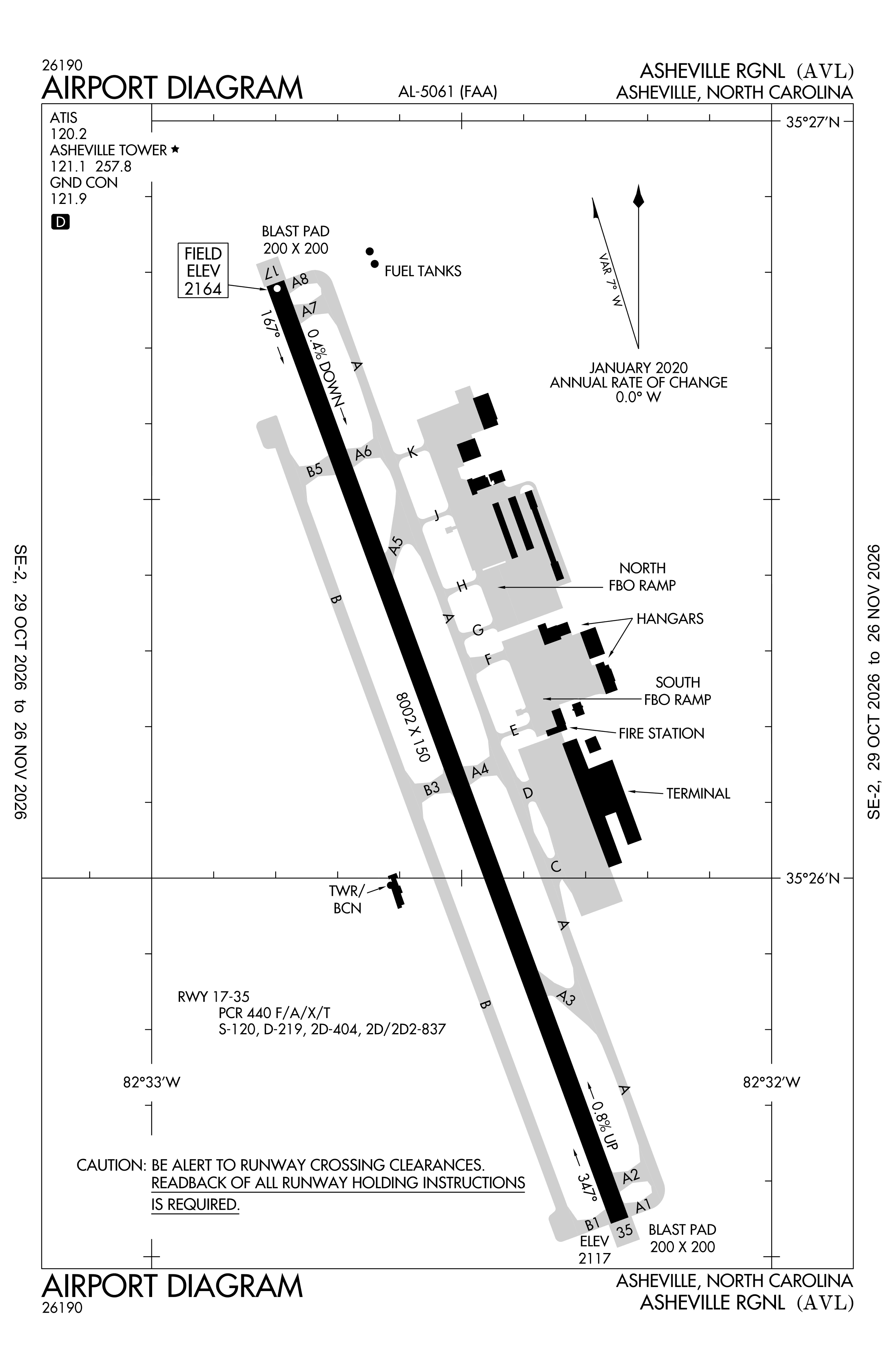
Redrawn by cwsi.net from the FAA airport diagram, cycle 2611, effective Oct 29 to Nov 26, 2026, and OpenStreetMap. Reference only, not for navigation.
FBOs and services
FBOs
 Signature Asheville40 Lindbergh Lane, Fletcher, NC 28732+1 828-687-7110Hours: 24 hours a day/7 days a weekARINC 130.275Signature page
- Landmark Aviation
FBO details may be out of date. Call ahead to confirm services and hours.
Not listed? Send a correction.
As of Nov 3, 2026.
Related
- Interactive NOTAM search for KAVL (category filters, maps, share links and a NOTAM decoder)
- Asheville Regional Airport: codes, map and current weather
- AVL weather and runway winds (METAR and TAF in plain English)
- Flights at AVL now
- NOTAMs for other US airports
More NOTAMs in North Carolina
Times are UTC (Z). Plain-English explanations are generated by cwsi.net from the NOTAM abbreviations and may simplify; the original NOTAM text is authoritative. NOTAMs come from the FAA NOTAM Management Service; cwsi.net refreshes its copy every 3 minutes. cwsi.net is not affiliated with the FAA: always confirm NOTAMs through official sources (a standard briefing or FAA NOTAM Search) before flight.